
"The Bill"-
Fishing the Williams Fork
by Karen Christopherson
The Williams Fork - very well known to some. I'm surprised it doesn't have a nickname like so many other favorite flyfishing rivers in Colorado - the Pan, the Fork, the Poudre - why not "The Bill"?
Ah well, regardless, fishing this river is a pleasure as it is just the right size and loaded with fish. It sits in a serene, quiet setting away from highways and is pretty easy to get to. Admittedly, the closest parking is over one mile away. But the walk is pleasant, taking about 30 minutes over fairly level ground. Better yet, take your mountain bike and cut the journey down to about 12 minutes (and you don't have to be pro biker either - no downhill kamikaze stuff unless you want to!)
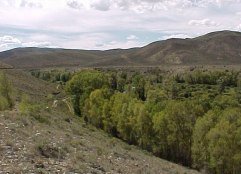 |
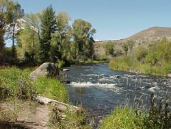
| A view of the lush Williams Fork valley nestled in hilly, sagebrush country. |
This river starts near the Continental Divide to the west of Berthoud Pass. It basically parallels the Blue River and both are main tributaries for the Colorado River. The Williams Fork is free-flowing for most of its route, and fishing is possible as it travels through Arapaho National Forest land. Its entire journey is something like 45 miles, but it's the last two miles that are the best known for flyfishing.
A variety of water
The best fishing is below Williams Fork Reservoir, very close to US Hwy 40 and the town of Parshall. Public access is available on the Williams Fork and the Colorado River at the Kemp and Breeze Units, leased by the Div. of Wildlife. The Denver Water Board controls the flows from the dam, and water levels can fluctuate from day to day. They also control the land directly below the dam, which is closed to fishing.
|
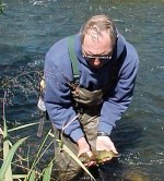
| A fat, healthy brown |
|
There are about two miles of access available, from the confluence with the Colorado upstream to a short ways below the dam. Here you will find a variety of water with paths along the shore. Wading is possible in much of the river unless the flows are high. Presentation is key to these wary browns and rainbows who will rise for dries, but make sure you have a selection of nymphs with you.
 Buy a paperback or ebook on The Colorado River: A Fly
Fisher's Guide by Al Marlowe and Karen Christopherson which
includes color maps and info on the Colorado and its main
tributaries (Blue, Eagle, Fraser, Roaring Fork, Fryingpan and
Fraser). The book is over 170 pages and includes info on
access, flies, hatches, and more.....available from
Barnes and Noble Or
on Amazon
Buy a paperback or ebook on The Colorado River: A Fly
Fisher's Guide by Al Marlowe and Karen Christopherson which
includes color maps and info on the Colorado and its main
tributaries (Blue, Eagle, Fraser, Roaring Fork, Fryingpan and
Fraser). The book is over 170 pages and includes info on
access, flies, hatches, and more.....available from
Barnes and Noble Or
on Amazon
 Click here to buy digital downloadable Ten Colorado Fishing Maps which includes the
Colorado River.
Click here to buy digital downloadable Ten Colorado Fishing Maps which includes the
Colorado River.
- Regs - from the dam at the reservoir to the Colorado River is catch and release, fishing with artificial flies or lures only. State regs above the reservoir.
- How to get there - Take Hwy 40 west from Granby or east from Kremmling. You can park near Parshall and move up the Williams Fork from its confluence with the Colorado. Or turn south, just east of Parshall, on the road to Williams Fork Reservoir (County Road 3). You'll see the DOW parking area on the west side of the road about 1/3 mile south of the Colorado RIver. Follow the pat about 1 mile to the river.
- Camping is available for free (!) at the Williams Fork Reservoir and at several of the access areas on the Colorado River. There are also several USFS campgrounds on the Williams Fork above the dam.
- Need a place to stay? Check out Williams Fork Lodging
- Check stream flows and reports before you go.