
Lots of Variety:
The Yampa River
by Karen Christopherson
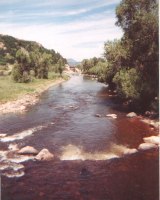
From the Flattops to the Green River, the Yampa has a long run of it. Starting in the mountains, this river traverses mostly high, dry rangeland and canyons. The flyfishing varies as much as the terrain. The Upper Yampa holds cold-water species whereas warm-water species are found downstream at river's end. Somewhere in-between, the two meet with opportunity to fish for trout and pike in the same river spot.
The Yampa is most popular as a floating river - this is a great way to see the scenery and fish at the same time. Plus you don't have to worry about hunting down access - let someone else do the worrying about getting in and out of the river while you JUST FISH! However, there are numerous access points where you can do walk and wade or bank fishing.
Access- Wading or Shore
The Colorado State Parks, BLM,
and DNR systems provides access points to the river, for fishing
or for boat/raft take-in/take-out. They are: from upstream to
downstream --
CSP=Colorado State Parks
BLM=Bureau of Land Management
SWA=State Wildlife Area
| White River Nat'l Forest - headwaters Take Hwy 131 south from Steamboat to town of Yampa; turn southwest on Cnty Rd 7, Forest Rd 9 and follow the Bear River (a tributary of the Yampa) upstream; several lakes and creeks |
| Stagecoach State Park (CSP)
Take Hwy131 south from Steamboat (off US40) for about 5
miles; turn south on Cnty Rd 14 and go 7 miles; access to
river below dam. They have their own
fishing report and info page.
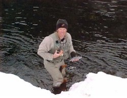
Mike Wall, ranger at Stagecoach, took this photo of winter fishing in the tailwater. |
 |
Service Creek (SWA) Take Hwy131 south from Steamboat
for 4.5 miles; turn southeast onto Cnty Rd 18 and follow for
7 miles (roads are confusing in this area)
|
| Steamboat Springs - You can fish in town - all catch and release - watch out for kayakers and rafters |
|
Parks Headquarters at the Yampa River (CSP) - open
Spring 2000 - Go west from Hayden on US 40 about 2 miles.
Access to the south. OR go west from Steamboat about 27
miles. OR go east from Craig on US 40 about 15 miles.
|
Double Bridges (CSP)
Go west from Hayden on US40 for 2 miles; access on south
side of highway
|
| Yampa River (SWA) Go east from Craig on US40 for 7 miles, OR west from Hayden for 6 miles |
| Craig - Access in town at Craig Golf Course and Loudy Simpson Park. Warm-species downstream from here |
South Beach (CSP) Go south from Craig on Hwy 13 for 3
miles
|
Duffy Mountain (CSP) Go west from Craig on US40 about
19miles; turn souht on Cnty Rd 17; travel about 10 miles and
cross the river. Follow road to signed access area
|
Juniper Canyon (CSP) Go west from Craig on US40 for 20
miles; turn south on Cnty Rd 53 travel 3.6 miles to Cnty Rd
74; turn right and go about 0.75 miles.
|
Maybell Bridge (CSP) Go west from Craig on US40 for 28
miles; access on south side of highway
|
Sunbeam (CSP)
Go northwest of Maybell on Hwy 318; follow 6 miles to Cnty
Rd 23, turn south and go 1 mile to access point
|
East Cross Mountain (CSP) Go west from Maybell on US40
for 14.5 miles; turn north on Cnty Rd 85 and travel 2.5
miles to BLM Road 1551. Turn west, go thru gate, continue
1.5 miles to access.
|
| Cross Mountain (BLM) A wilderness study area. Go west from Maybell on US40; turn north on Deerlodge Park Rd and follow to parking area. |
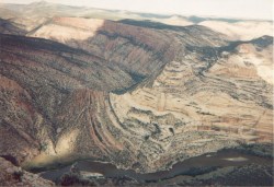
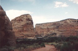
Dinosaur National Monument - Most access is by
floating. There is access at east end of monument. Take the
Deerlodge Park Rd north off of US40 (near Maybell) to access
the Yampa. From here is 46 miles of river to the other
reasonable access at Echo Park, where the Yampa and Green
meet. A very historic and beautiful place!
|
|
| Looking down on the river and spectacular country |
 |
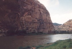
| Echo Park |
 |
Resources/Other Info:
 Click
here to buy an Ebook about Trout on Colorado
State lands - includes a lot of info about 150 Colorado fishing lakes and streams
Click
here to buy an Ebook about Trout on Colorado
State lands - includes a lot of info about 150 Colorado fishing lakes and streams
 Click here to buy digital downloadable Ten Colorado Fishing Maps which includes the
Yampa River.
Click here to buy digital downloadable Ten Colorado Fishing Maps which includes the
Yampa River.
The BLM has some good info on floating the Yampa - BLM Yampa website
See the website for State Parks of Colorado - Yampa River Legacy
Visit the website for White River National Forest
Rules for the Yampa
- Catch and release for 2 areas: Stagecoach Dam downstream for 0.6 miles; and Walton Creek downstream to James Brown bridge in Steamboat
- Fishing with artificial flies and lures for 2 areas: Stagecoach Dam to Catamount Lake; and Walton Creek downstream to James Brown bridge in Steamboat
- State regs on rest of the river in Colorado. Except, no bag and possession limit from Hwy 394 bridge near Craig downstream to Green River for channel catfish, largemouth and smallmouth bass, northern pike, walleye, green sunfish, bluegill, bullhead, and crappie.